A weekend trip up the beautiful Noosa river in the Cooloola section of the Great Sandy National Park.

Lake Cootharaba before the wind started
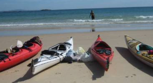
With six people and three cars, we made an early start and were on the water at Elanda Point, Lake Cootharaba, soon after 9 AM. Strong winds forecast arrived soon after. We had a rough passage across the lake with breaking waves over the kayaks. Everyone got wet, but no one went over.

Between the islands
We recovered at the Kinaba Visitors Centre, then paddled between the islands, past Kin Kin Creek, and entered the sheltered Everglades at Fig Tree Point.

Sheltered water lillies

Noosa river from campsite 3
We made good time through the picturesque everglades with its reeds, paper-bark trees, banksia and many waterbirds including darter, cormorants, kingfishers and raptors. There was enough of a breeze to ruffle the reflections in the tannin stained water, for which the Everglades are famous. We lunched at Harry’s hut camp where we were visited by a large lace monitor. Then on to Camp 3 where we set up our tents.
In the afternoon it was a brisk six kilometre climb to the sand blow where we admired the magnificent views and took group photos.

The start of the walk to the sandblow

The walk to the sandblow passes through typical sandy heathland and dry eucalypt forest. These heathlands are a special feature of south east Queensland.

The sandblow is impressive in its own right. This is a part with views of the ocean

The view of the Everglades – through which we paddled – makes the walk to the sandblow worth it.

Well done all
We arrived back at the camp site after dark for our evening meal but were driven to our tents by rain at 8 PM. It rained hard for most of the night and we slept in.

Camping on the sand.
The Cooloola region was once a large sand island similar to Stradbroke, Moreton, and Bribie islands. It is also adjacent Fraser island in the north, and until relatively recent times connected Fraser to the mainland before Fraser became Australia’s second biggest island (Tasmania is the biggest).

Paddling back
Morning dawned bright and sunny. Most went for a walk along the Noosa river while the tents dried out. By 10 AM we were back on the water paddling back the way we had come, making good time, with everyone comfortable at six km/hr. After Harry’s hut, where we lunched, the weather closed in. By the time we reached the visitors centre it was raining again.
We donned spray skirts and cags then crossed the lake again in pouring rain and strong winds but not as wild as the day before, but continuing a long club tradition of wet and windy Lake Cootharaba crossings.
On the way home we stopped for coffee and refreshments, getting back to the shed after 6 PM.
Overall it was a good trip with enough sunshine to show off the scenery, but with the wind and rain providing excitement and challenge.
This is one of the most scenic trips we do. Google Earth has many photos of the Everglades and the sand patch. They give a good idea of what it is like. This is a very beautiful paddle on an unspoilt river. Have a look at pictures from the report from previous trips in 2006 and earlier.
We will pack the kayaks on the trailer on Friday evening, 2nd, as we must make an early start if we are to climb to the sand patch and get back before dark.
We will meet at the shed at 5.40 AM on the Saturday 3rd morning to finalize packing with the intention of departing at 6 AM and being on the water at Elanda point by 9 AM.

|
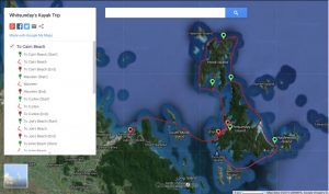
We will kayak across Lake Coothariba to the Kinaba Visitors Centre (4.18 km) then on to Fig Tree Point (1.25 km). We will continue up the Noosa River to Harry’s Hut (4.56km) and then to Camp 3 (6.34 km) where we will set up our tents and have lunch. Total distance 16.3 km so it is not too difficult, with 4 hours for the trip – including the stops.

|
Sand Patch
We will set up our camp and have lunch so that we can depart on the climb to the Sand blow by 2 PM. (see map) This is a 6 km steady climb, and we will walk fast as it will take the full 4 hrs to get there and back (12 kms) and still give us time to enjoy the fabulous views.

|
Sunday
On Sunday 21st we will have an early morning paddle further up the river while the tents dry out. In the past it has been magical in the early morning mist with crystal clear reflections. We will have a late breakfast, pack up and return the way we came. We should get back late afternoon and have time to unload.
Packing Kayaks:- Friday 2nd at 5 pm – Three volunteers are needed to help load boats.
Departure: Meet 5.40 am Saturday 3rd at the shed. Depart 6 AM
Route: (See map) Go North via the Bruce Highway. Turn off to Pomona (Avoid going to Cooroy) and follow the signs to Boreen Point. Shortly before you get to Boreen Point there is a sign to Elanda Point. Just before you get to the Elanda Point Camp site turn right and drive down to the lake to an area where we can unload kayaks and leave the cars.
Info: Cooloolah National Park map where we will paddle, and general information about the QPWS Cooloolah National Park (Broad park map)
Extra info: Local map of the area, Satellite map, and General information for kayaking in the area
Time: Saturday 3rd to Sunday 4th of September 2011
Duration: 2 days (overnight)
Distance: 35 km kayaking – Sat: 16.5 km (3-4 hrs) and 12 km walk (4 hrs) and ~ 20 km paddling on Sunday (3-4 hrs)
Paddle type: Sea kayaking
Accommodation: Camping. If you lack some (or all) camping gear, please let the organiser know. The club may be able to supply you with some (be early and book it with the leader).
Basic Costs: QPWS camping fees ($5.30). Petrol money to whoever you get a lift with. A wear and tear contribution of $20 for those using club gear (if you are genuinely unable to afford this speak to the leader).
Limits and requirements
Numbers: will be limited by the number of cars and sea kayaks available
Skills: Have demonstrated ability to do wet exits and T-rescues in a sea kayak (attend training day on 21st August – or contact the leader about it early so that something else can be arranged)
Fitness: Able to maintain a speed of 4 km/hr in a sea kayak for over an hour without a rest. Generally this means you can paddle from the club pontoon to 6 mile rocks and back in under 1 hour 30 minutes. Alternately, from the club pontoon to the radio mast at Long Pocket one way in 1 hour 8 min or both ways in under 2 hrs 15 minutes. Most beginners will attain this easily if they attend some of the training sessions, and paddle 2 -3 times a week trying to do these distances each time.
Bring: You will need a small tent (share if you can), a sleeping mat and a sleeping bag. We are not guaranteed good weather and it can be cold in September so bring something warm if the weather gets bad – something warm to kayak in that can get wet and something warm (and dry) for afterwards. Bring something waterproof in case it rains.
Sea kayaks are not totally watertight. You will need to put everything that should not get wet into dry bags. The club has a limited number of bags, tents and mats. If you don’t have what you need then book them with the leader well ahead and consider how much you can get into them and the kayak (quite a lot) when packing. It has to be small enough to get through the hatches.
There are no fires so bring a camping stove of some sort, or arrange to share with someone else. Trangia’s or gas stoves are usual. Bring a plate, mug and utensils. Also hats, sunglasses, sunscreen, insect repellant etc. You will need light at night so bring torches/lamps etc.
Food
Bring one breakfast (Sunday), one evening meal (Saturday), two picnic lunches, and a supply of snacks to eat along the way. Prepared evening meals which only need heating are good. People usually group up to bring meals and share between them. Most of us bring something tasty to share around during stops, before dinner, or after coffee. A beer or a glass of wine on Saturday evening is great after all the exercise. If you have more than this you won’t be on future trips!
Water: There is no water. We will need 2L per person per day for kayaking and walking and at least one extra litre for cooking and other matters. So bring between 6 and 8 L water each.
Kayaking gear: Lake Cathooraba is shallow and when the wind comes up in the afternoon or if there is a storm then it can get choppy and rough. For this reason we will wear PFDs, and take skirts and paddle leashes even if we don’t use them (they have been used here before).
Risk Assessment: Lake Coothariba is shallow and except for small areas can be walked out of.
Leader (also register with) : Michael Wynne (email: treasurer)
Deputy leader: Cora Skaien (Email president)
Register, as early as you can, by email with the leader. We need to book camp sites soon. Places and equipment will generally be on a first come first serve basis.
Please indicate whether you are able to bring a car, how many you can take, whether you can carry a kayak on roof racks, and whether you can tow a trailer.