The planned North Stradbroke trip has been postponed due to unfavourable forecasts (wind). This is an alternate plan.
A two night camping trip paddling Clarrie Hall Dam, the Tweed and Rous rivers, and then the Brunswick River.
| Event ID: 230106S |
We will paddle Clarrie Hall Dam on Friday (16 km), followed by paddling the Tweed and Rous rivers on Saturday (23 km), and then the Brunswick River on Sunday (21 km). We will set up camp for Fri and Sat nights at the Misty Mountain campsite near Clarrie Hall dam.
We will take sea kayaks and/or sturdy TKs. Tides will mostly assist on Sat and Sunday. We should be sheltered from wind for the most part.
Note that Sat and Sun paddles are a little longer than the 15km for a grade 1 paddle so if you are a beginner paddler please test yourself via your regular paddling on the Brisbane river. They will also be tide assisted which will help (Spring tides).
Fri: Clarrie Hall Dam
On Friday we will drive down to Crams Farm Reserve on the south end of Clarrie Hall Dam where we’ll put in. We’ll then spend 2 hrs exploring the western side of the dam until we get to the dam wall where we will get out and have lunch below the dam wall (~ 1 hr). We’ll then paddle back along the eastern side of the dam, exploring until we return to the put in point.

This is an unusual dam as it is an unusual shape and most sides are steep and forested, with many area to explore. There is a lot of water plants on the dam, and we will paddle around these.

Friday Schedule
- 6:30 AM Meet and load gear at shed
- 7:00 AM Depart shed
- 8:30 AM Meet at Tumbulgum for quick coffee (10-15 min)
- 9:30 AM Arrive Cram’s Farm Reserve
- 10 AM Depart and explore left hand side of Dam
- 12 PM Noon – Lunch at Dam wall
- 1PM depart and continue exploring left and side of dam
- 3 PM Arrive and Pack
- 3:30 PM depart
- 3:45 PM Arrive camp site (Misty Mountain Campsite)
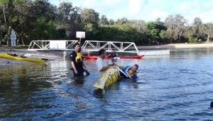
Level and Algae alert Check: Algae rating Green (Blue-green algae detected. Water safe for domestic, stock and recreational use.)

Sat: Tweed and Rous River paddle
We will paddle from Tumbulgum up to Murwillumbah along the Tweed river. We will cross to the Rous river via Mayal Creek (a channel just east of Murwillumbah), and then return to Tumbulgum after entering the Rous river.

Saturday Schedule
- 8:00 AM Depart campsite
- 8:15 AM Arrive and setup (?local coffee)
- 9:00 AM Launch and paddle up Tweed River
- 11:00 AM Enter Mayal Creek
- 12:00 PM Enter Rous
- 12-1 PM Lunch – along river (or paddle 1.2km upstream to Pat Smith Alf Colefax Park)
- 1 PM Paddle to Tumbulgum along Rous River
- 3 PM finish
- 3:30 PM Return to Campsite or relax and early dinner at Tumbulgum

Cnr Riverside Drive and Fawcett St., Tumbulgum NSW
SUN: Brunswick River to Mullumbimby (and back)
We will paddle with the tide along the Brunswick river from Memorial Park in Brunswick Heads to the park on the south side of Federation Bridge at Mullumbimby. After lunch we will return with the tide to Brunswick Heads.

Sunday Schedule
- 8:00 AM Depart campsite
- 9:15 AM Arrive
- 9:45 AM Launch and paddle up Brunswick River
- 11:45 PM Lunch – in park along river (downstream of Bridge at Mullumbimby)
- 1 PM Return Paddle
- 3 PM finish
- 3:30 PM Return to Brisbane
- 5:30 PM Arrive Shed
- 6:00 PM Return home

DETAILS
| Paddle Type | Flatwater |
| Start Date | 6-01-2023 |
| End Date | 8-01-2023 |
| Trip days | 3 |
| Paddle days | 3 |
| Trip Leader | Martin Wynne |
| 2IC | TBC |
| Grade | 1 (note that the distances are a little longer than grade 1, but there will be some tide assistance. If you are note sure of these distances (or you do not know), then this trip may not be for you). |
| Distance(s) | Fri: 16 km Sat: 23 km (tide assistance) * Tweed River (8.8 km) * Mayal Creek (4.5 km = to bridge (3km) + to Rous (1.5 km)) * Rous River (9.2 km) Sun: 21km (tide assist) 10.5 km each way |
| Paddle Duration(s) | Sun – 4-5hr Mon – 4-5 hr |
| Tide(s) | SAT (n/a) Murwillumbah Bridge * LOW 5:23 AM * HIGH 12:17 PM * LOW 6:52 PM Rous River (Dungay Creek Entrance) * LOW 5:49 AM * HIGH 12:43 PM * LOW 7:18 PM Tumbulgum * LOW 5:18 AM * HIGH 12:12 PM * LOW 6:47 PM SUN Brunwick Heads (Boat harbour) * HIGH 10:34 AM * LOW 5:27 PM Mullumbimby * HIGH 11:24 AM * LOW 6:01 PM |
| Moon | Full moon on the 7th Jan (Spring tides) |
| Sunrise – Sunset times | Sunrise: 5:28-5:56 AM Sunset: 7:48 – 8:14PM |
| Put in / Take Out Point | Fri * IN / OUT: Crams Farm Reserve * LUNCH: Clarrie Hall Dam wall (east) Sat * Tumbulgum (end of Fawcett Drive) * LUNCH: Dulguigan Road access next to Rous river, near north exit of Mayal Creek Sun * Memorial Park, Mona Lane (on the bend), Brunswick Heads * LUNCH: Heritage Park West Boat ramp (Mullumbimby) |
| Departure time (put in) | Fri:10 AM Sun: 9 AM Mon: 9:45 AM |
| Alternate Route Variations | Friday * Explore the inlets less and take a more direct route. Saturday * We may go 1.2 km up the Rous river from Mayal Creek for lunch at Pat Smith Alf Colefax Park (cnr Urluip Rd and Dalguigan Rd), depending on progress * Return via Tweed river Sunday * Return earlier |
| Alternate Take Out Points | Clarrie Hall Dam * exit at the dam wall Tweed river * Condong pontoon * Budd’s Park Southern side of Tweed river at Murwillumbah Mayal Creek (Channel) * Queensland Rd Bridge Rous River * Alf Colefax Park (cnr Urluip Rd and Dalguigan Rd * lunch site (Dalguigan Rd) Brunswick River * South side of Federation Bridge, Brunswick Tce, Mullumbimby |
| Facilities | Fri: Public toilets at Crams Farm Sat: Toilets at Tumbulgum Sun: Toilets at Banner Park (adjacent to Memorial Park). None close at Mullumbimby – walk down Tincogan St until service station ( Dalley St) or Public toilet (McCougan’s Lane) Camp: Toilets / showers / water etc |
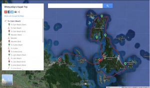
Route Maps


1 Mona Lane Brunswick Heads
Nearest Medical Help
Murwillumbah District Hospital Ewing Street, First Floor (Adjacent to front Entrance of Hospital), Murwillumbah, NSW 2484 ( 000 or (02) 6672 1822 )
Risks and Management
| Risks | |
| Sea Kayak Risk Assessment Club risk assessment on request. | ✓ Algae; ✓ Animals and Plants (major injury); ✓ Animals and Plants (minor injury); ✓ Bad Weather / Weather Change; ✓ Boat Traffic / Shipping; ✓ Capsize; ✓ Carrying Boats; ✓ Cuts, Sprains, and Strains; ✓ Dehydration; ✓ Drowning; ✓ Enter / Exit Boat; ✓ Equipment Failure; ✓ Fitness / Fatigue; ✓ Getting Separated from Group; ✓ Heat Exhaustion / Hyperthermia; ✓ Hit by Paddle; ✓ Hypothermia; ✓ Ineffective Rudder; ✓ Medical Condition(s); ✓ Missing / Broken Paddle; ✓ Paddle Related Injuries / Tendonitis / Blisters; ✓ Panic / Fear; ✓ Rocks and Submerged Objects; ✓ Separation from Boat; ✓ Sinking Boat; ✓ Strainers (Overhanging Trees / Mangroves / Fishing Lines / Structures); ✓ Sunburn; ✓ Tripping while walking; |
| Travel Risk Assessment Club risk assessment on request. | ✓ Becoming Lost; ✓ Breakdown or Breakdown in Remote Area; ✓ Chemical: Unleaded Petrol; ✓ Drowsiness while Driving; ✓ Incident or Accident while Driving; ✓ Injury from Loading / Unloading Equipment from vehicle; ✓ Loads Falling from Vehicle or Trailer, or hitting occupants in accident; ✓ Towing Trailer; |
| Risk Management | |
| Paddler Requirements | ✓ Conditions can be calm, but can change dramatically with winds and tides contributing significantly to this. ✓ Paddlers must advise leaders if they have health issues or injuries that may affect participation. Ensure medication is carried and is accessible. If unsure, they should check with their doctor beforehand. ✓ Participants must be familiar with, and have demonstrated, a wet exit while a member of the club if using a spray deck. ✓ Participants need the skills for the grade for the trip, unless modified below (Additional Comments). |
| Emergency Contact Information | * Emergency 000 |
| Nearest Medical Help and Contacts | Murwillumbah District Hospital Ewing Street, First Floor (Adjacent to front Entrance of Hospital), Murwillumbah, NSW 2484, Australia Ph: (02) 6672 1822 Marine Rescue Brunswick Heads (02) 6685 0148 General Emergency: 000 |
| Safety and Personal Equipment | |
| Personal Equipment (check link) | ✓ Clothing you can get wet (on the water); ✓ Dry clothing (to keep warm); ✓ Equipment Requirements for Grade; ✓ Food adequate for trip duration; ✓ Footwear suitable for paddling, swimming and extra for on land; ✓ Paddle clothes to protect from cold/wind (e.g. thermal/spray jacked or cag); ✓ Review potential equipment; ✓ Sun protection (hat, sunglasses, long sleeved paddle clothes, sunscreen, etc); ✓ Water – 3L per day (4L if camping); ✓ Water and snacks accessible while paddling; |
| Kayak Equipment | ✓ Dry bag; ✓ PFD and paddle; ✓ Paddle tie; ✓ Pump, sponge, bailer, and paddle float; ✓ Suitable paddle craft ✓ Whistle; |
| Safety Equipment | ✓ First Aid Kit; ✓ Hand Pump (at least 1 per 2 boats); ✓ Paddle Floats (at least 1 per 2 boats); ✓ Repair Kit; ✓ Rescue Stirrup; ✓ Spare Paddle; ✓ Torch / Glow stick; |
| Communications | ✓ Flares; ✓ Mobile Phone; ✓ PLB/EPIRB; ✓ Signal Mirror; ✓ V-Sheet; ✓ Whistle; |
| Additional or Emphasised Equipment | * tents as we will be camping. * Sleeping mats and Bags * Cooking gear, although we will probably eat out / get takeaway on Sunday evening * some cash in case! |
| Check of Paddlers’ Equipment | ✓ Bailing Device; ✓ Footwear (covered); ✓ Medication; ✓ PFD; ✓ Paddle Leash; ✓ Suitable Craft; ✓ Sunsmart Gear; ✓ Water; |
Logistics
Boat Loading | 6-01-2019 6:30 AM |
| Boat Loading Location | Club Shed |
| Boat Loading Details | We will pack boats and gear the morning of the trip. |
| Meet Location | Club shed |
| Meeting Time (meet location) | 6:30 AM |
| Depart Time (meet location) | 7:00 AM |
| Costs | Accommodation: 2 nights about $40 each ($20 per night) – bring cash or it costs more! Petrol costs to driver (cash) Wear and tear cost ($10 per day ) Money for coffee, local cafe and/or restaurant food. |
Registration
| Register with: Martin |
| Register by: 5 Jan 2023 Event ID: 230106S Alternative trip plan – registrations closed (email direct (or SMS if able)) |
Event organisers and leaders: Check registrations here (copy the event ID first). Login required.