Gladstone – 256km | 128km
Local: Brisbane Airport | Brisbane Marburg | Sunshine Coast / Hervey Bay | Northern NSW
North Qld:
Gladstone | Mackay | Bowen | Townsville | Cairns | Weipa

Note
Eastern standard time is UTC+10
LM: Aug 06


The University of Queensland Canoe Club
Fun and Fitness
Local: Brisbane Airport | Brisbane Marburg | Sunshine Coast / Hervey Bay | Northern NSW
North Qld:
Gladstone | Mackay | Bowen | Townsville | Cairns | Weipa
Eastern standard time is UTC+10
Local: Brisbane Airport | Brisbane Marburg | Sunshine Coast / Hervey Bay | Northern NSW
North Qld:
Gladstone | Mackay | Bowen | Townsville | Cairns | Weipa

Eastern standard time is UTC+10
Local: Brisbane Airport | Brisbane Marburg | Sunshine Coast / Hervey Bay | Northern NSW
North Qld:
Gladstone | Mackay | Bowen | Townsville | Cairns | Weipa

Eastern standard time is UTC+10
Local: Brisbane Airport | Brisbane Marburg | Sunshine Coast / Hervey Bay | Northern NSW
North Qld:
Gladstone | Mackay | Bowen | Townsville | Cairns | Weipa

Eastern standard time is UTC+10
Local: Brisbane Airport | Brisbane Marburg | Sunshine Coast / Hervey Bay | Northern NSW
North Qld:
Gladstone | Mackay | Bowen | Townsville | Cairns | Weipa

The Marburg radar station is higher than the airport radar and more westerly. It can miss light rain detected by the airport radar. However, the airport radar is utilised elsewhere several times a day. You should carefully check the time and date of the last airport radar image
Eastern standard time is UTC+10
Local: Brisbane Airport | Brisbane Marburg | Sunshine Coast / Hervey Bay | Northern NSW
North Qld:
Gladstone | Mackay | Bowen | Townsville | Cairns | Weipa

The Marburg radar station is higher than the airport radar and more westerly. It can miss light rain detected by the airport radar. However, the airport radar is utilised elsewhere several times a day. You should carefully check the time and date of the last airport radar image
Eastern standard time is UTC+10
Local: Brisbane Airport | Brisbane Marburg | Sunshine Coast / Hervey Bay | Northern NSW
North Qld:
Gladstone | Mackay | Bowen | Townsville | Cairns | Weipa

The Marburg radar station is higher than the airport radar and more westerly. It can miss light rain detected by the airport radar. However, the airport radar is utilised elsewhere several times a day. You should carefully check the time and date of the last airport radar image.
Eastern standard time is UTC+10
Local: Brisbane Airport | Brisbane Marburg | Sunshine Coast / Hervey Bay | Northern NSW
North Qld:
Gladstone | Mackay | Bowen | Townsville | Cairns | Weipa

The Marburg radar station is higher than the airport radar and more westerly. It can miss light rain detected by the airport radar. However, the airport radar is utilised elsewhere several times a day. You should carefully check the time and date of the last airport radar image.
Eastern standard time is UTC+10
Local: Brisbane Airport | Brisbane Marburg | Sunshine Coast / Hervey Bay | Northern NSW
North Qld:
Gladstone | Mackay | Bowen | Townsville | Cairns | Weipa

Eastern standard time is UTC+10
Local: Brisbane Airport | Brisbane Marburg | Sunshine Coast / Hervey Bay | Northern NSW
North Qld:
Gladstone | Mackay | Bowen | Townsville | Cairns | Weipa

Eastern standard time is UTC+10
 A social paddle to the West End Markets. A chance to catch up with members and meet new ones, do some browsing/shopping and take in some food, caffeine, West End vibe, and maybe music. Back around midday / Lunch. Arrive on time!
 Spend a day in Moreton Bay paddling around Coochiemudlo Island learning or refreshing the basics of Sea Kayaking including rescue techniques and safety.
 Our semester trip to Wivenhoe Dam to try out all the tippy boats in nice clean fresh water. A great social day out to push your limits and improve your skills. Optional barbecue.
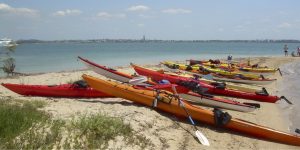 A day paddling in Moreton Bay to Green and St. Helena Islands. Possibly around St. Helena depending on conditions and the group.
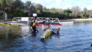 A multi-disciplinary day building on introductory trips. A chance to practice and learn new skills. Details and registration will be posted in due course.